
|
My Personal Web Site |
|
...discipline is a habit of taking consistent action, |
|
Home |
|
My Interests |
|
My Photos Gallery |
|
My Favorite Links |
|
Downloads |


|
Downloads 2 of 5 |
|
• The solution – Assuming that your GPS, may be connected on a computer, and get loaded new waypoints and tracks… – …then, you may prepare the spatial data on your computer, store them for later use, and just before commencing your trip, load them on your GPS device. • The process – There is a rich set of alternatives, on creating waypoints and paths on your computer. By the time, this is getting more and more easy, higher accuracy, and lower or zero cost. – One of those alternatives, would be to use: • GoogleEarth Plus™ to assist you on identifying spatial information and creating the original digital information (data). • Your GPS manufacturer, PC-based software, to transfer your created data, onto your GPS device. In our example, this software is the MapSource™ by Garmin. More information on how to use productively this program, can be found in the “G2Gx User Guide”. |
|
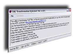
G2Gx This program transforms “kml” files, into “gpx”. • The problem – You need to plan a trip, expecting all the support and guidance you can get from your GPS device. – However, most of the locations (waypoints), and most importantly, the route (path/track) itself, are not provided by your current GPS device. |

|
GoogleEarth Plus™ and GoogleEarth™ |